Yellowstone National Park Part One
CampsitePhotos.com begins tour of Yellowstone National Park!
I left Curt Gowdy State Park last Tuesday after one last campfire and a glimpse of the full moon.


My destination was Seminoe State Park, about 160 miles west. From the town of Sinclair, next to Rawlins, it’s a 32 mile drive north on a two lane road.

The North Platte River said hello for a few miles and the weather was nice.

Unlike the campground.


It did have lots of flies, though. I swatted about 150 and a pair of magpies would swoop in and eat them. Like little squished raisins.
The overcast dawn the next morning allowed me a chance to kinda get a photo of the hail damage to my car’s hood.

It’s a lot worse seen in person. I left without taking any campsite photos.
I drove 300 miles northeast to Buffalo Bill State Park just west of Cody. The whole center of Wyoming is high desert with hardly any trees.

But at least there were several areas of construction to break up the monotony.

I arrived at Buffalo Bill around 6:00pm and did not even bother unhooking the trailer.

When they raised the dam level in 1993 it wiped out the original campground. The new one is right along the eastern entrance road to Yellowstone. Like all Wyoming State Parks it has vault toilets and no showers. I left early the next morning without taking photos, except one of the lake at sunrise.

I liked Keyhole and Curt Gowdy State Parks in Wyoming. That’s it. The main attraction in the state is Yellowstone and that is where I headed Thursday morning, first stopping in Cody at Wal-Mart for supplies.
There were a bunch of RV’s in the parking lot. I forgot that I could have spent the night for free. I wish I had saved the money. Someone even set up a tent in the corner of the parking lot.

Had not seen that before.
I followed Chief Joseph Highway north so as to enter Yellowstone from the northeast entrance.

It’s a beautiful scenic road that quickly gains several thousand feet in elevation. Then goes down and then back up. Which attracted at least 5000 bicyclists. There was some big race going on.

They were heading south and I saw them for at least 30 miles. I entered Montana briefly at the town of Cooke City.

And then four miles later was this place.

The sky turned blue with puffy clouds. The birds starting singing. The green intensified.

Would it finally stay sunny? No rain for at least one day? Not a chance.
Yellowstone. You need to picture the layout so I will help you. In your mind imagine a four inch circle. Now step on it a bit so the top and bottomed are flattened. Draw that on a blank piece of paper just above the middle. Now draw another one just like it immediately below it, with the bottom of the first touching the top of the second. Like a squished number eight. Make sure they touch for about three inches. North is at the top and south is at the bottom.
The perimeter is called the Grand Loop Road. Let’s add some stuff to the top oval of the eight. At about the two o’clock position draw a three inch line northeast. That leads to northeast entrance. Put at dot where the line leaves the oval. Label that Tower Fall. An inch up the line place another dot and label it Slough Creek. Another inch up make another dot and label it Pebble Creek.
Back to the top oval. At the eleven o’clock position make a dot and label it Mammoth. At the ten o’clock position make a dot and label it Indian Creek.
Now, where the two ovals join on the left, make a dot and label it Norris. Where they join on the right make a dot and label it Canyon.
On to the south oval. At the nine o’clock position make a dot and label it Madison. At the bottom of the oval draw a three inch line heading south, straight down. A half inch down the line make a dot and label it Grant Village. Two inches down the line make a dot and label it Lewis Lake.
Back to the south oval. At the four o’clock position make a dot and label it Bridge. At the three o’clock position make a dot and label it Fishing Bridge.
Those are the twelve campgrounds in Yellowstone. See, that was easy.
I stayed at Pebble Creek for three nights, Thursday through Saturday.

There were four fires burning in the park when I arrived. The road in the lower oval of your map from Canyon to Fishing Bridge was closed. The ranger at Pebble Creek complained about the drought they were having. I told her not to worry. Help had arrived.
I quickly set up camp in number 19.

An hour later the skies darkened and the rain began to fall.

The ranger stopped by to thank me.
Friday morning was sunny, so I walked the campground. There are only 27 sites here but several are near the creek.


I had put my solar shower out in hopes of getting it a least lukewarm.

While waiting I cooked the 5 pounds of ground beef I had bought in Cody at the Wal-Mart. Some of it went towards a nice cheeseburger lunch.

The rest was for taco meat.

The ranger stopped by again as I was cooking. She told me that this section of the park, the northeast, was where most of the grizzlies congregated. She explained about proper food storage and how to be bear aware. She talked about bear spray and I stopped her.
“Isn’t bear spray just pepper spray?”
“Yes, but not like regular pepper spray. Instead of a stream it comes out like a fog. The idea is to create a cloud that the bear won’t come through.”
I thought about this.
“My tacos are very spicy. Maybe I could throw some of those at a bear?”
“No, you miss my point.”
“Could I try some of your bear spray on my tacos?”
“No, listen, we take this very seriously here. Make sure to store your foodstuffs properly, either in your vehicle, a bear-proof container, or a bear box.”
I assured her that I would and she left.
She stopped by an hour later as I was cleaning up.
“I just wanted to check that your food is secured. I have some, err, concerns.”
“No worries. I made certain that my taco meat is in bear-proof containers.”
I showed her what I did.

“See, there is no way a grizzly with his big claws could get those rubber bands off. Plus, there are latches on the side.”
She started shaking her head.
I asked, “So do the bears come by often?”
“Not all the time. There is one old male, though, that has claimed this area as his territory. We call him scarface.”
“Why? Does he look like Al Pacino?”
She mumbled something under her breath and walked away.
The solar shower had warmed up enough that I was able to use it. My last real shower was at Custer on August 14th.
Saturday morning I went for a drive to check out Slough Creek and Tower Fall campgrounds.

This is another small campground with only 23 sites. Like Pebble Creek, these are both first come first served and fill up each afternoon. The creek is bigger here.

And there are some sites right on the water.

Nifty.
I continued on.

They were doing road construction in this area with half-hour delays so I didn’t get to see the waterfall.

But the campground was nice with 32 sites like number 13.

On the way back to camp I ran into another traffic problem. A big hairy one.

The northeast entrance road, that line you drew on your map, goes through Lamar Valley. In addition to grizzlies, there are bison, wolves, and elk that call this area home.


This guy gave me the evil eye.

On your map, the bison were between Slough Creek and Pebble Creek. The skies started to darken.


And back at camp…

Needless to say, the fires were out after 3 days of Moisture Man in the house.
Sunday morning I left at dawn. I had reservations for a week at Canyon and decided to drive the upper oval counter-clockwise to avoid the construction.
The Lamar Valley was beautiful and the hairy tacos were still asleep.


My plan was to stop by Mammoth and Indian Creek on my way to Canyon, which is not always easy while dragging a trailer. I checked out the pools at Mammoth first, after finding somewhere to park.
You can barely see my rig in the center of the next photo, about 1/2 mile away from one of the main parking lots.

At this point in the trip my hiking shoes have almost no tread left on them. They slipped several times on the gravel path leading to where I took the above photo. I thought about putting on my hiking boots. I should have put on my hiking boots. That would have saved me from the injury later on…
Anyway, there are several boardwalks throughout the hot springs area.

At the top you get a good view of the Mammoth Lodge.

Along the way is a neat formation called Mounds Terrace.


Steamy.
I skipped back to my car and drove a mile north to Mammoth campground.

It is only about 6200 feet high and has that high desert feel. There are 86 sites with an RV loop on the outside, with sites like number 51.

And a tent loop on the inside, with sites like number 73.

There is a trail from the campground to the lodge area that has a store and a restaurant and other goodies, like Fort Yellowstone.
I continued south for 10 miles to Indian Creek campground.
Aren’t you glad you made the map?

There is a creek here, aptly named Indian Creek.


The 73 sites vary from open to shaded, mostly shaded, like number 21.

Notice the tarp over the table? Yep. That’s because of me.
I continued south to Norris and then east to Canyon. I will stop back at Norris later as there is a museum and some thermal features to check out. And I was getting hungry.
I checked in at Canyon and went to my site. The picnic table was too close to the fire pit so I attempted to move it. These are heavy tables consisting of four 4 inch by 12 inch by 6 foot planks bolted to a steel frame. Must weigh close to 200 pounds. Not easy to move.I grabbed it, lifted and started to drag it. My treadless shoes, combined with the wet soil, caused my right foot to slip. The table fell from my grasp and the steel frame landed on my right big toe. It really hurt. But I shook it off and had some tacos and an adult beverage.

My toe was throbbing all night but my moans were drowned out by the rain hitting the trailer. So at least my neighbors couldn’t hear me.
Monday morning I looked at it. Quite swollen with a rainbow of colors under the nail. Canyon has showers and laundry facilities, which I had planned on using anyway, so I slipped on some sandals and headed there.
I showed my toe to one of the park staff and he said that unless I did something I would lose the toenail and be in a lot of pain for a while.
I thought about this while I hobbled into the shower and afterwards started my laundry.
Then I went back to him to ask more questions. He was quite knowledgeable about toes.
“The toe,” he explained, “consists of the nail, then a membrane, and then the meat with a bone inside. The dark blue color you see is the blood that has gotten between the nail and the membrane. It causes pressure that will make the nail detach from the membrane and that is not good. If left alone, the whole nail will separate and eventually fall off. It will be very painful and you will not be able to wear any type of shoe for a couple of weeks.”
“So what is the solution?” I asked.
“You need to get a hole drilled in the nail to let the blood out so that the membrane can reattach itself to the nail. There is a clinic down by Fishing Bridge. I’ll call them for you.”
He did and they wanted $157 just to walk in the door and another $100 for a hole. Yeah right.
He said there is another solution.
“What you do is take a small drill bit and carefully, by hand, drill a hole in the nail, in the center of the blue part. As soon as you are through the nail the blood will come out. You have to be careful not to drill through the membrane or it will probably get infected and you could possibly lose the toe.”
I thought about it. I have some drill bits. I decided to give it a go. At worst I will still have nine toes left. Long story short, I successfully performed the operation and am in recover mode!
Your Comment:

Beverly Beach State Park
Oregon
Beverly Beach State Park is in forest-sheltered area right on the Oregon coast and is a very popular campground featuring a beautiful trail to and along miles of sandy beach.
View Campground
Essential Camping Gear and Equipment
Get everything you need to enjoy your outdoor adventures from bags and packs to air beds and sleeping bags, insect repellant, cooler bags, and 2-burner stoves.
Shop Now
Unique RV Camping
Over 2,000 Wineries, Breweries, Farms and more!
Harvest Hosts is a special type of membership club for RVers, offering overnight RV camping accommodations at 2,365+ locations across North America!
Learn More
Experience RVing
Take the Family on a Perfect Road Trip! Rent an RV from RVshare
Find Cheap RV Rentals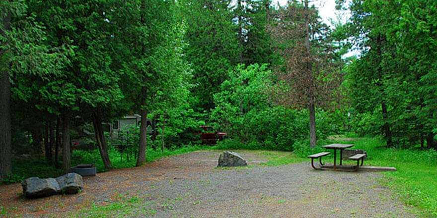
Jay Cooke State Park
Minnesota
Jay Cooke State Park offers one of the best places for bikers, backpackers, horseback riders and skiers to hook up with the Willard Munger State Trail.
View Campground
Anastasia State Park
Florida
Anastasia State Park has 139 campsites that are close to the beach and can accommodate tents, trailers and RVs.
View Campground
Great Deals on Top Rated Camping Gear
Find everything you need for camping, including hiking supplies, tents, coolers, sleeping bags, cots, survival & first aid, food processing, and more!
Shop Now
Douthat State Park
Virginia
Douthat State Park has a total of 87 single family campsites and some have wonderful views of Douthat Lake. The Park also has 35 cabins and lodges for rent.
View Campground
Take the Family on a Perfect Road Trip!
Save up to 25% on your family travel costs in 2021 by booking an RV through RVshare
Find Cheap RV Rentals
Lake Perris State Recreation Area
California
Lake Perris offers a variety of water recreation, including swimming, fishing (shore, pier and boat), boating, sailing, waterskiing, and a special area for scuba diving.
View Campground
Banning State Park
Minnesota
Banning State Park Campground has 34 single-family campsites and is located in a forested area near the Kettle River with plenty to discover.
View Campground
Pawtuckaway State Park
New Hampshire
Pawtuckaway State Park Campground has 292 campsites and is located on the shores of beautiful Pawtuckaway Lake. Many having views of the lake.
View Campground
Drill? There’s an eaiser method and it’s the one the Doctor probably would have performed. Open a paper clip, or a suitable piece of stiff wire. Holding with pliers, heat the wire to red hot. Place the tip of the wire on the nail, in the center of the blood clot. It will melt through the nail and the blood will spurt. I’m surprised Mr Ranger didn’t know this method.